

A redesign of Franklin and Quay Streets by the Department of Transportation with plans to rearrange 15 parking spots and add a protected two-way bike lane is in the works, Brooklyn Paper reports.
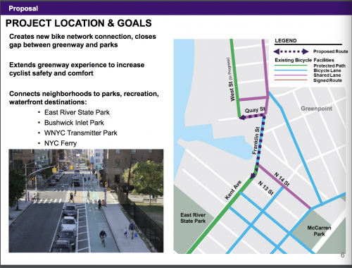
The proposal (available here) is part of a larger DOT plan to make commuting by bike easier and safer along the often perilous route through Greenpoint starting where Kent Avenue and Franklin Street meet; existing issues identified in the proposal include:
• Gap in the protected bike lane network between Kent Ave two-way bike path and West St two-way path
• Challenging transition from Kent Ave to Franklin Ave with increased bicycle volumes along a truck route
• Limited eastbound access from West St – Quay St and Calyer St are westbound”
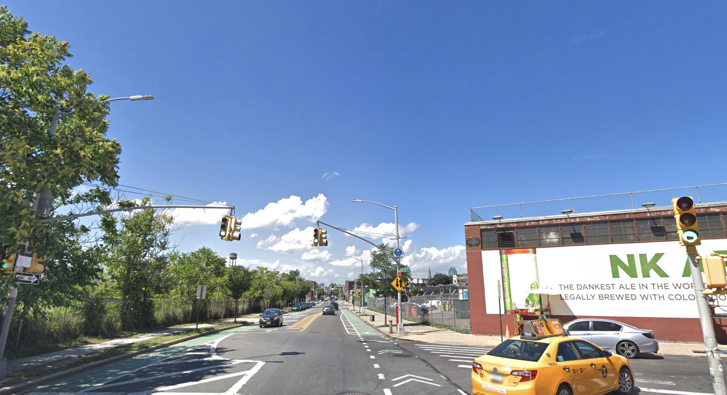
Franklin Street has become especially congested in recent years with heavy truck and construction traffic, the added B32 bus route, more waterfront residents resulting in an increased number of cyclists and runners competing for space on the two-way street.
–
Designs that include protected bike lanes on city streets result in a 15 percent reduction in “all crashes an injuries,” the proposal claims.
A separate Dept. Of Transportation study released last year found that since 2014, 90 percent of bike fatalities in NYC happened on streets without bike lanes with more than 40% of bicycle fatalities occurred in Brooklyn; out of the record 29 cyclist deaths in NYC last year, 18 occurred in Brooklyn.
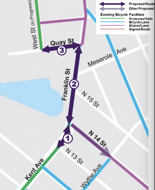
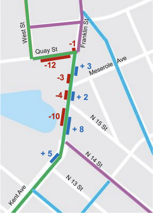
The project segments are divided into three sections: Kent Avenue from N. 13th Street to N. 14th Street, Franklin Street from N. 14th Street to Quay Street, and Quay Street from Franklin Street to West Street.
Franklin Street is a truck route now without a painted bike lane in its most dangerous stretch, making it especially unsafe for cyclists.
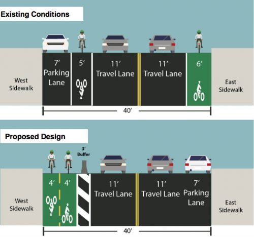
Current bike lanes on the opposite sides of Franklin Street would be consolidated side-by-side on the western side of the street and a concrete barrier would add protection.
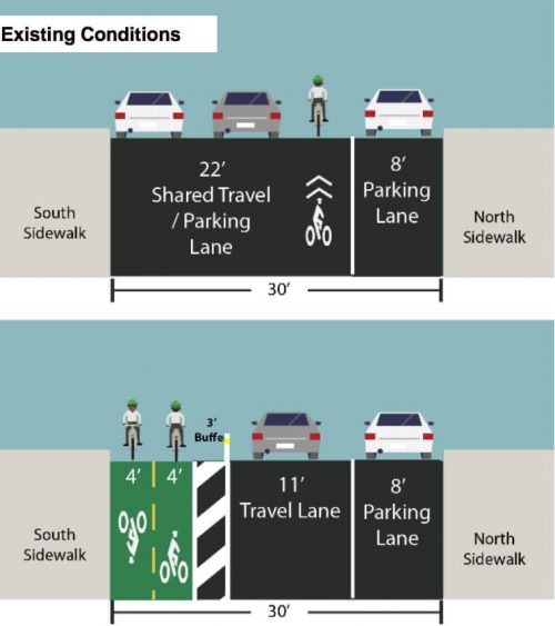
Quay Street’s western side would also receive the same treatment under the DOT proposal with a two-way lane bike lane with plastic separators, similar to the new Grand Street protected bike lane installed this week.
A removal of the B32 bus stop on the western side of Franklin Street at Meserole Avenue will have to consolidated and the DOT is exploring options on where to have a replacement bus stop.
The total number of parking spots would be reduced by 15 along the quater mile route.
The website StreetsBlog inquired with the DOT asking why the protected by lane isn’t being extended for the entirety of Franklin Street, and this is DOT’s response:
DOT investigated several design options including removing parking. Our proposal is to relocate parking from the west curb to the east curb along this portion of Franklin Street in order to accommodate deliveries and retain curb access for neighborhood businesses. We are in the final stages of transferring ownership. When the transfer is complete, DOT will add green paint and vertical delineation to deter/limit vehicle incursion on the bike facility. The vertical elements can be added over the winter, and paint will be implemented in late spring after the weather warms up. Cyclists wishing to take a more direct route may remain on Franklin Street.
A protected bike lane would be fantastic! This section between Williamsburg and Greenpoint always feels dangerous to me. Cyclists currently need to switch sides of the road at Kent and N14th which can feel risky with the truck traffic.
Also the signage for cyclists has been unclear on Quay st. Until recently it seemed to be a two way bike lane despite it being a one way street. Now the signs to seem to indicate riders heading south on West st should take a left onto Oak st and then a right onto busy Franklin st. The intersection of Franklin st and Calyer st. is particularly congested and unclear. Excited for this to be improved – keep up the good work DOT!