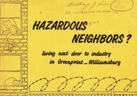
It’s been a busy couple of weeks in the world of toxic chemicals, specifically as they pertain to Greenpoint. First, Neighbors Allied For Good Growth (NAG) released the ToxiCity Map to bring confusing, widely scattered publicly available data together into one cohesive document. Now, we’re bringing you the long-lost 1980s factory-to-factory survey of Greenpoint and Williamsburg by Hunter College, a study that many lifetime Greenpoint residents say they couldn’t find or easily access until now.

It reveals the former locations and quantities of reactive chemicals — the kind that explode when they make contact with water, such as cyanide. In many cases, they’re shockingly close to residential buildings in Brooklyn’s priciest real estate drag. From speaking with a NAG member at the map release event, I also found that the “Hazardous Neighbors” study contains information that’s not available in the ToxiCity Map.

Conducted by the Community Environmental Health Center at Hunter College, the “Hazardous Neighbors” study was released in 1989 and all but forgotten.

Thankfully, the contamination it highlighted wasn’t. After increased pressure from the community, Greenpoint’s Maspeth Holders (storing 32 million cubic feet of natural gas and visible throughout all five boroughs) were demolished in 2001. Then, Greenpoint won a state lawsuit against Exxon Mobil filed in 2007 to clean up the oil spill, and 50 Kent Ave.  (Brooklyn Flea) will begin remediation of a “significant amount of coal tar” this year, joining a long list of other remediated NYC brownfield and Superfund sites.

v

Though a lot has changed for the better, there’s still a long way to go for the soil of North Brooklyn, and many residents, particularly recent transplants, have little awareness of the history and scale of contamination in the area. The elusiveness of this study is somewhat, and in small part, to blame.

Earlier this month, the Greenpoint Waterfront Alliance For Parks and Planning held a North Brooklyn ‘toxic history talk’ with Mitch Waxman, Newtown Pentacle writer/historian, and Geoff Cobb, author of “Greenpoint Brooklyn’s Forgotten Past.” Some of the people in attendance mentioned the Hunter College study and how hard it was to access:

A longtime resident recalled: “They [Hunter College researchers] had a court order, and they went in and counted the number of barrels and pounds [of chemicals] stored.”

A 1989 study by the Community Environmental Health Center At Hunter College, “Hazardous Neighbors.”

To provide some context, the 1984 Bhopal, India disaster was the industrial explosion heard around the world, which killed thousands of people living nearby and got New York City officials worried about a potential industrial massacre occurring in Greenpoint and Williamsburg.


North Brooklyn was selected for the study due to its “heavy concentration of industry in close proximity to residences.”


Greenpoint and Williamsburg (CD1) had exponentially more industrial land (12% of CD1 tax lots were for manufacturing, compared to .2 – 5.3% for other NYC districts) than the average NYC neighborhood, thanks in part to its lack of political organization among a working-class immigrant population.

1985 land-use graph, Community Environmental Health Center At Hunter College, “Hazardous Neighbors.”

The 16 bulk storage facilities in Greenpoint and Williamsburg stored a combined “89 million gallons of oil and gasoline, 32 million cubic feet of natural gas, and 20 million gallons of liquefied natural gas.”

Oil and gas storage by volume: “Hazardous Neighbors” by Hunter College

Leaks were a major problem with the storage of oil and gas, especially with underground tanks: “Leaks in underground fuel storage tanks are very common; one study by the Environmental Protection Agency estimated that 35 percent of tanks currently in use leak.”

1988 Monitor St. spill of 60,000 gallons of oil was contained: “Hazardous Neighbors” by Hunter College
Con Edison’s bulk storage facility at 214 Kent Ave. was the largest in capacity. “Hazardous Neighbors” study. Image: Google Maps

 The Con Edison storage tanks near S. 1st and Kent Ave. were demolished in 2011.

The removal of Con Ed oil storage tanks from S. 1st and Kent Ave. in 2011. Image: Curbed

The remediation is completed in this area of Williamsburg’s Kent Avenue, where people now call the coastal land home.

Greenpoint also had its fair share of oil storage woes related to the Exxon Brooklyn Terminal and its 25 underground storage tanks, as well as a truck loading transfer station that distributed more than 40,000 gallons of gasoline per day.

The Exxon Brooklyn Terminal on Newtwon Creek was a major source of contamination: “Hazardous Neighbors” by Hunter College

Radiac’s continued operation was also called into question at the GWAPP ‘toxic history’ talk. Mitch Waxman was surprised that Radiac is still open for business, given the transformation of Kent Avenue. Watch Waxman’s description of the site below:

Despite its location near PS 84, Radiac is apparently still in operation today at 261 Kent Ave., the only storage facility of its kind in the city that handles “low-level” radioactive waste.

Community Environmental Health Center At Hunter College, “Hazardous Neighbors.”

The Radiac storage facility directly next door at 33 S. 1st St. is no longer a toxic warehouse, but according to the survey, did store five materials on the EPA’s list of extremely hazardous substances.

Community Environmental Health Center At Hunter College, “Hazardous Neighbors.”

Meanwhile, over on the North side of Williamsburg is McCarren Park, currently grappling with its own lead problem that Bedford + Bowery recently wrote about:

There’s more than twice the amount of lead than is considered ideal for a recreational area in the soil at McCarren Park, at least in the sample we gathered from around the trunk of a large tree near the handball courts on the Union Avenue side.

Although childhood lead poisoning in NYC has declined over the past decade, we are not in the clear: Greenpoint has the highest rate in the city, according to the Department Of Health (DOH). The DOH links this to lead paint exposure in the home. Indeed, Williamsburg has a colorful history with lead, as “Hazardous Neighbors” reveals. 

It turns out that Williamsburg’s Bedford Avenue used to host NJZ Colors (formerly named Reichhold Chemical Company)  near McCarren Park at 105 Bedford Ave., a factory that manufactured neon-orange lead-based paint. According to the report, NJZ Colors was fined for 18 workplace violations by OSHA inspectors during one onsite inspection in 1983.

Community Environmental Health Center At Hunter College, “Hazardous Neighbors.”

Here’s more on Williamsburg’s lead paint legacy:

Community Environmental Health Center At Hunter College, “Hazardous Neighbors.”

A friend of mine who lives directly on top of the former NJZ site knew nothing about the history of the area moving in, and it’s likely his neighbors don’t know either.

Also just down the street from McCarren Park is the area’s first Starbucks on N. 7 st., a former Superfund site that the team behind the ToxiCity Map couldn’t find records of. The corporate coffee giant opened up shop on top of Williamsburg’s former Service Plating, an electroplating operation that used highly toxic chemicals.  This information, while explicit and in some ways shocking, should ultimately help residents know and reconcile with our beloved neighborhood’s toxic past so that people, especially families and pregnant women, can make an informed decision about staying here long-term. The greater impact of all this information involves real estate full disclosure law, which protects uninformed landlords and developers from liability, so the burden is really on the renter or buyer to know — something people naturally don’t think about when considering the other billion and a half factors that go into securing housing in NYC. On the positive side of things, vapor intrusion mitigation systems work when properly installed and maintained.

I will follow up on this article soon with news on up-to-date research on TCE, one of North Brooklyn’s most prevalent contaminants, as well as what concerned residents can do about it. In the meantime, if you want to test your soil, scoop up a sample and send it to Brooklyn College’s soil testing lab for results. 

Join the Conversation

2

  1. Aaron
    I have a copy of the study by Hunter College in 1989: Hazardous Neighbors. I was cleaning out my storage unit and came across it. I lived on Bedford near North 11 st for many years. I unfortunately destroyed my files a while ago when I moved. They pertained to my engagement with the agencies involved re the lead contamination of the NJZ property and soil in McCarren Park when they were tearing the NJZ building down.
    You’re welcome to have my copy of this study if you’re interested. I will mail it to you. I do realize your article above is from 2015.

Leave a comment

Your email address will not be published. Required fields are marked *