

To shine a light on Brooklyn’s murky legacy of contamination, the Neighbors Allied For Good Growth (NAG) and Pratt’s Spatial Analysis and Visualization Initiative ( SAVI) released a beta version of a ToxiCity Map revealing the underground toxins of Greenpoint and Williamsburg. The map release event was held at the Sunview Luncheonette in Greenpoint last Tuesday, but in case you couldn’t make it, here’s a re-cap.
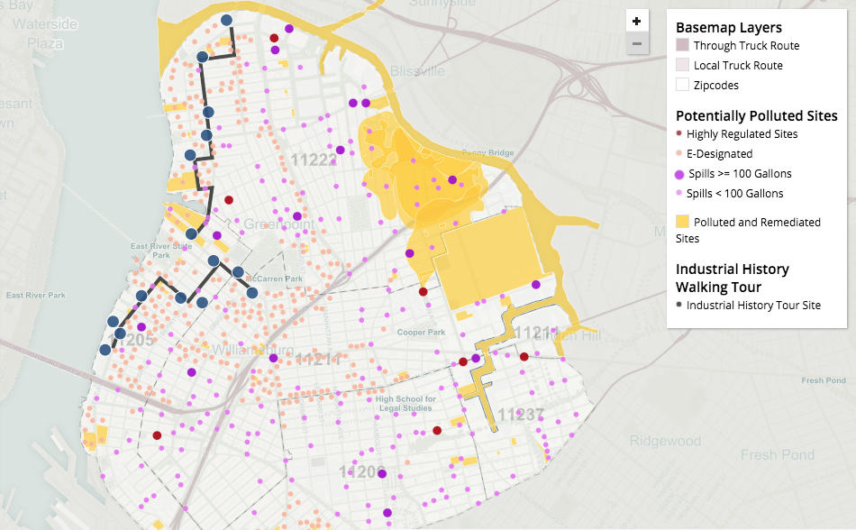
To get right to the point, the most significant contamination hotspots persist around Franklin and Dupont Streets (across from where Greenpoint Landing is going up) and McGolrick Park (which is host to stubborn dry cleaning plumes). There’s also the still-functioning and unsettling Radiac storage facility (cough…VICE employees may want to look into this), keeping things radioactive on Kent Avenue around the corner from PS 84.
It’s difficult to overstate the scale of North Brooklyn’s industrial past. From rope to refined sugar, pharmaceuticals to vinyl plastics, porcelain to pencils, Greenpoint and Williamsburg have a rich and varied manufacturing history.
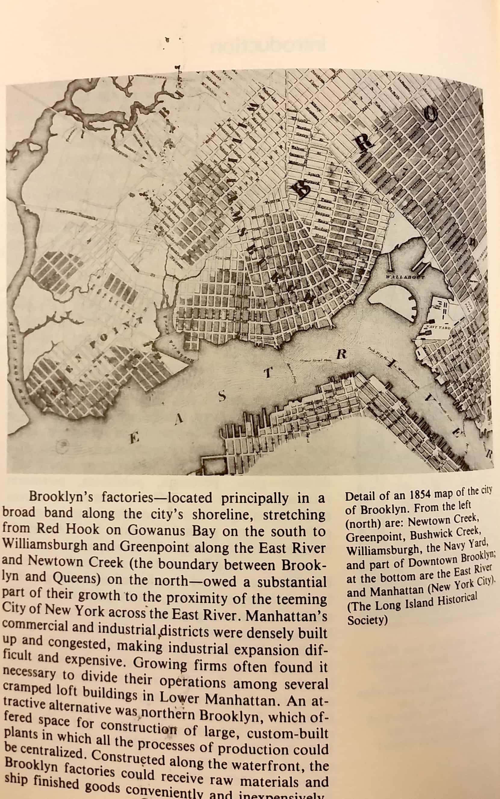
The two neighborhoods employed over half the population of the entire borough of Brooklyn at one point, and the three-and-a-half-mile-long Newtown Creek processed more freight tonnage than the entire Mississippi River during WWI. The creek became New York City’s premier destination for oil refineries and chemical processing.

While the former industrial buildings provide the much-hyped factory aesthetic that attracted many creative newcomers to the area, the land that they sit on sometimes contains dark, toxic secrets that can go unseen for years. Now, for the first time, we have a map that clearly shows where dangerous chemicals remain underground today (if you’re wondering, there’s a possibility that whatever’s in the ground can be released into the air that we breathe, but not all contamination poses an immediate threat to residents).
The map project received funding from the state Department of Environmental Conservation (DEC) and combined public data from three agencies: The Office of Environmental Remediation (city), the state DEC, and the Environmental Protection Agency (Federal).
While the map’s data was technically available to the public already, the information was hosted across separate websites that are unintuitive and full of jargon; the ToxiCity Map simplifies things. NAG board member Dennis Ward said the map’s function is to help locals “understand levels of impact and threat.” Watch the video below for a description from Ward:
Louis Kleinman, community liaison for the Waterfront Alliance, asked, “Besides scaring the hell out of a bunch of homeowners, how do you envision the usage of this thing? How will people be able to make use of this in a practical way?” (Ward responds in the video below).
“We’ve had cases with construction sites where all of a sudden there’s something bubbling up. ‘What is it? Is it good or is it bad?,'” said Ward.
“All that information is out there. Being able to access it and know what’s happening around you hopefully makes you more informed, hopefully gets you more involved, and if there is a construction site down the street and there is an issue, you can monitor it — you can be aware and know,” said Ward.
In the case of the NuHart Superfund site, where a massive pool of underground toxins is moving around with the water table, this knowledge proved helpful in informing the community and impacting real estate development.
NAG’s Emily Gallagher said:“I think there’s a false sense that people [developers] who are coming into the neighborhood to produce real estate in the neighborhood, which we’re gonna see a lot more of really soon, that they’re gonna fix it [toxic contamination]…there’s really two groups of people in the neighborhood: people who know the legacies and those who don’t.”
Gallagher said that a NAG member spoke up when developers first started eyeing the NuHart site, leading to a site investigation that revealed a pool of 40,000 – 60,000 gallons of liquid phthalates underground.
“If this person hadn’t kind of spoken up and said ‘I actually know there’s toxic chemicals under the ground there,’ who knows what would have happened with that development site,” she added.
Next week, on Nov. 2, there’ll be another meeting on the Nuhart Site. For those of you interested in attending, details follow below. Otherwise, check back next week for more coverage.

There were at least 3 large and essentially similar plastics factories in Greenpoint. One the NuHart site (which is now subject to much anxiety and scrutiny), a twin plant at the corner of McGuiness Blvd.and Dupont St, and a plastics factory at Noble St. and Franklin St. Is anyone checking whether the two sites OTHER than NuHart wee contaminated, and whether anything was done about them? The McGuiness site has some sort of residential component (!!), while the Franklin St. site is now home to the Expo Center. There they apparently just put up a new glass front, and I never saw any remediation going on (plus the owner has a checkered real estate past). Are there any other toxic underground plumes besides the one at Nuhart?
NuHart was designated a superfund in 2010 and sold to Dupont St Developers LLC in 2012. The Greenpoint Landing ULURP took place in 2013, during which NAG expressed no concern for the proposed school’s location in relation to the plume. During the 2013 ULURP Save Greenpoint (a group of volunteers) took it upon themselves to read the environmental impact statements and as a result filed a FOIL request to acquire more information about the plume and its location in relation to the school and raised this issue at the public hearings.
Save Greenpoint also learned the 2005 Greenpoint Williamsburg rezoning’s environmental impact statement did not account for increased rainfall when calculating the Combined Sewer Overflows. Increased demand for energy is another item of concern, for which Save Greenpoint sadly did not have time to address.
Growth is never good. With effort its damage may be minimized, but that requires respect for the environmental review process irregardless of its mere advisory role.